
Welcome to Great Basin National Park
Welcome to the Great Basin National Park Information Page.
Here you will find all you need to know about the natural history of the park.
Learn about the geology, trees, mammals, birds, or other plants and wildlife of the area.
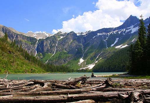
Great Basin National Park is a national park located in eastern Nevada, in the United States. The park covers an area of over 77,000 acres and is home to a variety of unique natural features, including ancient bristlecone pine trees, limestone caves, and the highest peak in Nevada, Wheeler Peak, which stands at 13,065 feet.
The park is known for its stunning natural beauty, and visitors can explore a variety of hiking trails, scenic drives, and interpretive programs to learn more about the park’s geology, flora, and fauna. Popular activities in the park include hiking, camping, stargazing, and wildlife viewing.
One of the park’s most popular attractions is Lehman Caves, a limestone cave system that features a variety of unique formations, including stalactites, stalagmites, and helictites. Visitors can take guided tours of the caves to explore their beauty and learn about their geological history.
Great Basin National Park is also home to a diverse range of wildlife, including elk, bighorn sheep, mountain lions, and a variety of bird species. The park is also home to several rare and endangered species, including the bristlecone pine tree, which is one of the oldest living organisms on the planet.
Overall, Great Basin National Park is a unique and beautiful destination that offers visitors a chance to experience the natural wonders of Nevada’s eastern landscape.
Getting There
Great Basin National Park is located in eastern Nevada, and there are several ways to get there depending on your starting location.
By Car: If you are driving, the closest major city to the park is Las Vegas, which is about 290 miles south of the park. From Las Vegas, you can take Highway 93 north to Ely, and then Highway 6 and 50 east to the park. Alternatively, you can take Highway 95 north to Highway 50 east to the park.
By Plane: The closest airports to Great Basin National Park are in Las Vegas and Salt Lake City, both of which are served by major airlines. From there, you can rent a car and drive to the park, or take a shuttle or taxi service.
By Bus: There are several bus companies that offer service to nearby towns, such as Ely, Nevada or Delta, Utah, from where you can take a taxi or rent a car to get to the park.
Once you arrive at Great Basin National Park, there are several scenic drives, hiking trails, and other attractions to explore. Keep in mind that some areas of the park may be inaccessible during the winter months due to snow and road closures, so it’s best to check ahead before planning your trip.
Directions
The main park entrance is five miles west of Baker, Nevada near the Nevada – Utah border. Driving distances from Salt Lake City is 234 miles, Las Vegas is 286 miles, Reno is 385 miles and Cedar City is 142 miles.
Establishment the Great Basin National Park
From the sagebrush at its alluvial base to the 13,063-foot summit of Wheeler Peak, Great Basin National Park includes streams, lakes, alpine plants, abundant wildlife, a variety of forest types including groves of ancient bristlecone pines, and numerous limestone caverns, including beautiful Lehman Caves.
Great Basin National Park was established on October 27, 1986. Prior to that time, the area existed as Lehman Caves National Monument, (established in 1922) and Humboldt National Forest’s Wheeler Peak Scenic Area. The park was established to set aside exceptional examples of the Great Basin region. Great Basin is a hydrologic region where all precipitation, whether in the form of rain or snowmelt, that occurs in the region stays in the basin where it either evaporates or filters down into underground aquifers never reaching the ocean. The region covers over 200,000 squares miles, extending from the Sierra Nevada Mountains in the West to the Wasatch Range in the east and from Idaho in the north to southern Nevada.
Great Basin National Park is one of the newest national parks in the U.S. Great Basin was set aside on 27 Oct 1986 by President Ronald Regan.
Lehman Caves National Monument was established on 24 Jan 1922. It was transferred from the Forest Service to the Park Service on 10 Aug 1933 and incorporated into Great Basin National Park on 27 Oct 1986.
Size – Acreage of Great Basin National Park
The Great Basin National Park includes much of the South Snake Range, a superb example of a desert mountain island. From the sagebrush at its alluvial base to the 13,063 foot summit of Wheeler Peak, the park includes streams, lakes, alpine plants, abundant wildlife, a variety of forest types including groves of ancient bristle-cone pines and numerous limestone caverns, including beautiful Lehman Caves.
Great Basin National Park consists of 77,180 acres of federal land.
Non-Federal Land – 0.00
Gross Area Acres – 77,180.00
The History of Great Basin National Park
The name, the Great Basin, comes from a peculiarity of drainage: over most of the area, streams and rivers find no outlet to the sea. Instead water collects in shallow salt lakes, marshes and mud flats, where it evaporates in the desert air. There is not just one basin here, but many, all separated by mountain ranges running roughly parallel, north and south. The landscape plays and replays a single magnificent theme of alternating basin and range – broad basins hung between craggy ranges – from the Wasatch Mountains of Utah to the Sierra Nevada of California in seemingly endless geographic rhythm. At first glance (or even after many miles of driving) you might think of it as monotonous landscape – nothing out there but sagebrush, a vast sea of pale green shrubs. Appearances are deceptive. As in the ocean, there is much life not immediately apparent. And above the valleys, rising thousands of feet from the sagebrush sea, mountain ranges form a high-elevation archipelago, islands of cooler air and more abundant water. Here we find a rich variety of plants and animals that could not survive in the lower desert.
Lehman Caves
Lehman Caves is a beautiful limestone cave with intriguing, unusual formations. Lehman Caves is one of the best places to see rare shield formations. Over 300 shields are known in Lehman Caves, more than any other cave. All of the cave is profusely decorated; stalactites, stalagmites, helictites, flowstone, popcorn, and other formations cover almost every surface of the cave.
Lehman Caves is a window into the past. Information about past surface climates are preserved in the layers of cave formations, while much can be learned about natural history from the “treasures” in old pack rat middens. Thus the cave has great potential for researchers to study both past climate change and the effects of climate change on plant and animal communities
Geological Dates:
- 550 million years ago the Pole Canyon limestone was deposited.
- 160 million years ago metamorphism of limestone occurred.
- 20 million years ago the Snake Mountain range was formed (uplifted).
- 5 million years ago Lehman Caves begins to form.
Archeological dates:
- 10,000 years ago is the estimated date that Native American settled the Great Basin area.
- 1,000 years ago Pueblo cultures inhabited the area probably forcing out the Fremont culture.
- 800 years ago human remains were deposited in the natural entrance of the cave.
Historical dates:
- 1826 – Jedediah Smith crosses Snake Range at Sacramento Pass.
- 1843 – 1844-John Fremont passes through eastern Nevada.
- 1859 – Mormons establish a settlement in Snake Valley.
- 1871 – Gold discovered at Osceola.
- 1873 – 1877-Osceola at its mining peak.
- 1885 – Ab Lehman discovers cave in the spring and had installed ladders and stairs throughout the cave by the fall, tours begin. (Discovery date is questionable.)
- 1891 – Ab Lehman dies in Salt Lake City, October 11.
- 1892 – C. W. Rowland buys Lehman’s ranch.
- 1909 – Nevada Forest Service established in the area surrounding the cave.
- 1912 – The cave is added to the Forest Service.
- 1920 – Clarence Rhodes takes control of the management of the cave.
. - 1922 – President Harding proclaims Lehman Caves a National Monument. Rhodes continues operation of the cave for the National Forest Service.
- 1933 – Lehman Caves National Monument is transferred to the National Park Service jurisdiction on June 10th.
- 1937 – Entrance tunnel was started and finished in 1939.
- 1941 – Electric lights installed in the cave.
- 1963 – New Visitor Center/Administration/Caf Building is dedicated.
- 1970 – Exit tunnel was completed.
- 1974 – Concrete trails installed in cave.
- 1981 – Talus Room was deleted from the regular tour route.
- 1986 – Great Basin National Park is established and Lehman Caves National Monument is incorporated into the Park on October 27th.
- 1997 – Algae is cleaned from the cave
Accessibility
Great Basin National Park offers a variety of opportunities to enjoy the area for those persons with disabilities. Much can be learned about Great Basin National Park from your vehicle and from facilities and programs that are accessible.
There is a wheelchair lift to assist users into the visitor center and access to the first room on the cave tour. Wheelchair accessible sites are also available at the picnic area and in the campgrounds. Should you need a sign language interpreter, let the park know ASAP and they’ll do everything they can to accommodate your request. If your group requires any other special accommodations, please let the park know in advance of your arrival.
Great Basin National Park Visitor Center
Parking and Restrooms – Designated parking spaces are available at the Visitor Center with a ramp over the curb. Ride the lift up to the main Visitor Center level, and enjoy the mural depicting the park along the way up. A drinking fountain, pay phone and unisex restroom are also available at this level.
Visitor Center – The Visitor Center is fully accessible. The Lobby, information desk, book sales area, Lehman Caves Cafe and Gift Shop, exhibits, and audiovisual programs are all on one level. Ranger activities held in or near the Visitor Center, such as patio talks, are also on this level. The Great Basin National Park slide show is captioned. A wheelchair is available for use in the Visitor Center and for entry into the first room of Lehman Caves. Ask for availability at the front desk.
Camping and Picnicking
There are three campgrounds within the park that have accessible sites. These sites are generally located next to accessible restrooms; Upper Lehman Creek Campground (site #2), Wheeler Peak Campground (site # 5), and Baker Creek Campground (sites # 11 and #27). Each campsite has a picnic table, fire grate, and tent pad. Check at the Visitor Center on water availability. Camping is on a first-come, first-served basis. When the campgrounds fill, these sites are made available for all campers. Note: Persons using the Upper Lehman Creek Campground restroom access ramp may require assistance, due to its steepness.
The picnic area near the Visitor Center has accessible restrooms and a cut curb provides access to a table and fire grate.
Backcountry / Backpacking
Registration for backcountry is strongly recommended. Backpacking opportunities abound, but there are few maintained trails. Routes generally follow ridge lines or valley bottoms. Plan ahead: bushwhacking through stands of mountain mahogany can be arduous–or impossible. Topographic maps, advice and information on current conditions are available at the visitor center.
Basic Visit Recommendations
Great Basin National Park and the surrounding areas offer a great diversity of recreational and scenic opportunities. Some highlights include the only glacier in the Great Basin Desert, 13,063-foot-tall Wheeler Peak, Lexington Arch, ancient groves of bristlecone pines, and beautiful Lehman Caves.
During snow season allow at least half a day to visit cave and explore visitor center. During summer allow at least a full day to explore the park, more if you enjoy hiking and exploring backcountry roads.
Biking
Bicycles are restricted to park roads and parking areas. Bicycles are prohibited on trails and in the backcountry. Mountain bikes are only allowed on designated motor vehicle roadways.
Camping
In Great Basin National Park, there are four campgrounds and a group camping area. Amenities include water (in summer), restrooms, fire rings and picnic tables. There are primitive campgrounds along Strawberry Creek and Snake Creek that have tables and pit toilets, but No Water. Only Lower Lehman Campground is open year round. The other campgrounds and primitive sites open as snow levels permit.
Cave Tours
Regularly scheduled tours of Lehman Caves are offered year round, more frequently in the summer.
Entrance Fees
Activity Fee
Cave Tour, 30 minutes – $2.00 One Time
The 30 minute tour visits the Gothic Palace where you can view all of the major types of cave formations found in Lehman Caves, and is wheelchair accessible. This tour is recommended for families with young children and infants. Cave tours are limited to 25 persons. Cave tours often sell out. To ensure space, buy your tickets early in the day or in advance over the phone. 775-234-7331 ext 242.
Cave Tour, 60 minutes – $6.00 One Time
This 0.46 mile walk through the cave visits several highly decorated rooms. The route passes by many shields, helictites, and fabulous draperies. Cave tours are limited to 25 persons. Cave tours often sell out. To ensure space, buy your tickets early in the day or in advance over the phone. 775-234-7331 ext 242.
Cave Tour, 90 minutes – $8.00 One Time
This tour is the longest offered, walking 0.54 miles through the cave, and visiting the spectacular Grand Palace where one can see the “Parachute Shield”. Children ages 4 and under are not permitted on the 90 minute tour. The limited attention span of younger children can detract from the enjoyment of other people on the tour. Cave tours are limited to 25 persons. Cave tours often sell out. To ensure space, buy your tickets early in the day or in advance over the phone. 775-234-7331 ext 242
Fishing
A Nevada fishing license is required for fishing.
Food and Supplies
A concessionaire operates a cafe and gift shop from April to October. Restaurants and small grocery store and gas station are available in Baker.
Hiking
Great Basin National Park is a mountain park. Roads and trails open seasonally as snow conditions permit. Summer months are the best for access to the high country. The road from town of Baker to park visitor center is open year round.
Tours of Lehman Cave takes about 1.5 hours. It is a .75 mile walk on a paved trail with stairways and indirect lighting. Dress warmly, the cave is a constant 50 F all year round. Those under 16 must be accompanied by an adult.
Horses
Horseback riding is allowed on some trails. Llamas, horses, and mules are allowed in the backcountry as pack animals on some trails. Scatter manure piles at trailheads and at backcountry campsites. Do not tie animals to vegetation. Use a picket or a nightline.
Lodging
There are four developed campgrounds, and limited backcountry sites. There is limited motel accommodations are available in Baker, Nevada. The nearest cities are Ely, Nevada at 70 miles to the west and Delta, Utah at 100 miles to the east.
Pets
Pets must be kept on a leash at all times. Leashes can not be over six feet in length. Pets are not allowed on trails or in the backcountry. There is only one place in the park pets can be tied and left unattended, for details and location consult the ranger on duty at the visitor center
Picnic Areas
There is a picnic area by the visitor center. Reservations for group picnic area should be made at least three weeks in advance. Fees for picnic area vary with group size.
Programs / Activities
Regularly scheduled tours of Lehman Caves offered year round. More frequently in the summer. Campfire programs, guided walks, and Junior Ranger programs offered Memorial Day to Labor Day.
Stop at the visitor center and take a tour of the cave. Drive the scenic road to the base of Wheeler Peak. From there, follow easy to moderate trails to alpine lakes and the bristlecone pine forest.
Visitor Center
Introductory slide show and exhibits available at visitor center.
The visitor center schedule
8:00 am to 5:30 pm PDT – Daily – Summer
8:30 am to 4:30 am PST – Daily – Winter
Closed: New Years, Thanksgiving and Christmas
Parking area is available for buses and RVs at visitor center. Wheeler Peak Scenic Drive is not recommended for large RVs or buses.
Weather of Great Basin National Park
This is a fairly arid region with most precipitation received during winter snows or summer thunderstorms. Winters are generally cool and summers are generally mild; however, weather conditions can change rapidly, especially at the higher elevations. Be prepared for all types of weather. Lehman Caves is 50 degrees F, 90% humidity year round, a jacket and suitable walking shoes are recommended.